
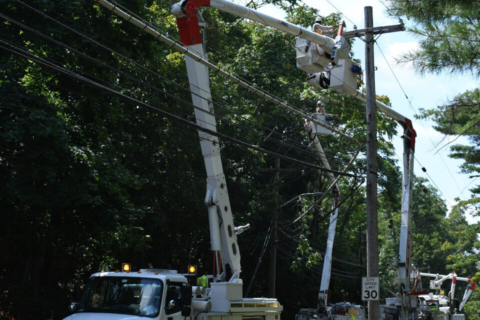
Utility Crews from Missouri Power Work to Restore Power in New York
New Hurricane Outlook a Formula for Epic Season of Tropical Disaster
Last Wednesday, the CSU Tropical Meteorology Project issued its August 5 forecast update for 2020. The first discussion takes place in mid-December about two weeks after the season ends on November 30. Updates in April and June provide a clearer picture of what the season activity might bring.
The December projection for the 2020 Hurricane Season began with 30 percent chance of a slightly above average season (12 or named storms,) and 15 percent chance of a well above average season (up to 16 named storms.)
In April, CSU shifted their outlook to an above average season including 16 named storms, 8 hurricanes, and 4 major hurricanes. On June 4, the forecast increased again from 16 to 19 named storms (12 is the average) with 9 hurricanes and 4 major hurricanes.
The CSU August 5 Forecast for 2020 Hurricane Activity has changed dramatically.
Long-range projections are just that. They give a picture of what could happen in the upcoming season. Weather forecasting beyond three days into the future is an inexact science that uses supercomputer models and many data sources. One model may give very different results from another model. The same applies to long-range tropical cyclone forecasts. The December discussion included five different scenarios for 2020, each with a different percentage. Two of those added up to a 45 percent chance of a more active than average season.
#Isaias is now post-tropical. Here's how the Atlantic stacks up with the average #hurricane season through August 4. 2-4 times average for most parameters so far. No major (Category 3+) hurricanes yet this year. pic.twitter.com/mjrMoZte7G
— Philip Klotzbach (@philklotzbach) August 5, 2020
Extremely Active 2020 Atlantic Hurricane Season
The CSU forecast now calls for an “extremely active 2020 Atlantic Hurricane Season” with 24 Named Storms, 12 Hurricanes, and 5 Major Hurricanes with an Accumulated Cyclone Energy (ACE) of 200. NOAA’s forecast is very similar, but with ranges of up to 25 named storms, 11 hurricanes, and 6 major hurricanes.
For comparison, the 1981-2010 average is 12.1 named storms, 6.4 hurricanes, 2.7 major hurricanes, and an ACE of 106.
Forecasts now indicate a 75 percent chance that a Major Hurricane will hit the US Coast.
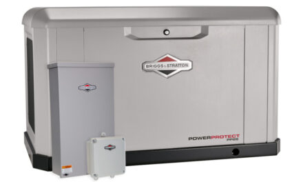
Best Natural Gas Generators for Hurricane Power Outages
In a series of tweets, Philip Klotzbach of the CSU Tropical Meteorology Project team cited weak vertical wind shear, a very active West African monsoon season, warm Atlantic Ocean temperatures, and extremely low odds of an El Nino this summer and fall.
Seasonal forecasts use various of indicators including the El Nino Southern Oscillation (ENSO.) The state of the ENSO in the equatorial Pacific Ocean affects cyclone activity in the Atlantic Basin. An El Nino results from a warmer than average Pacific Ocean. A La Nina is cooler than average.
A La Nina that coincides with the hurricane season brings more tropical cyclones to the Atlantic Ocean. As the Tropical Pacific Ocean cools, the Tropical Atlantic Ocean warms. Warm oceans coupled with the right atmospheric conditions allow tropical cyclones to develop.
Early forecasts predicted the possibility of an ENSO shift to neutral, average Pacific Ocean temperatures to a mild La Nina or slightly cooler than average temperatures.
In Stock Portable and Standby Generators Ship in 1-2 Days
2020 marked the sixth consecutive year that Atlantic tropical cyclones formed before the season started. Tropical Storm Arthur formed on May 16 out of a depression in the Caribbean and came close to Cape Hatteras, North Carolina, before turning out to sea. Eight days later, Tropical Storm Bertha drenched Florida before it made landfall in South Carolina with 65 MPH Wind Gusts.
Although hurricanes and tropical storms can form throughout the year, they are most common from June 1 through November 30. It is unusual, though not unprecedented, for two tropical storms to form outside of the regular hurricane season.

The new 24kW Generac with PWRview ATS runs automatically during a hurricane power outage to help keep your family and home safe, even during outages that last for weeks.
Seasonal forecast from @ColoradoStateU increased & now calls for extremely active 2020 Atlantic #hurricane season: 24 named storms (including 9 that have already formed), 12 hurricanes (including 2 that have already formed) & 5 major (Cat 3+) hurricanes:https://t.co/wL1t2D2mgx pic.twitter.com/DfZgG3CAyC
— Philip Klotzbach (@philklotzbach) August 5, 2020
NOAA's *Updated* 2020 Atlantic #HurricaneSeason Outlook now calls for: 19-25 named storms, of which 7-11 could become hurricanes, including 3-6 major hurricanes.
— NOAA (@NOAA) August 6, 2020
Graphics at https://t.co/mJuHVNZbnG @NWS @NWSCPC #HurricaneOutlook #ItOnlyTakesOne pic.twitter.com/GUNX3vany8
A Hurricane Season for the Record Books
Just two months into the 2020 season, storms have broken one record after another. If the trend continues, more records are yet to come. Cristobal, the earliest third named storm in history, formed on June 2 out the remnants of the Pacific Tropical Storm Amanda. It initially weakened as it moved over the Yucatan Peninsula, but strengthened into a tropical storm before it moved back over the warm Gulf of Mexico and raced across the Gulf into Louisiana. Cristobal headed north and weakened to a depression just before it reached Arkansas.
How to Use a Portable Generator for Emergency Power
It remained tropical cyclone organization and strength all the way to Central Wisconsin before it became a post tropical depression. After passing close to the waters of Green Bay, a portion of Lake Michigan, it moved over the Michigan Upper Peninsula. While over Lake Superior, Cristobal gained strength as an extra-tropical storm before moving over Ontario. It was the longest-lived tropical cyclone over the Midwest on record.
Every 2020 storm since Cristobal has set a record for the earliest named storm in history.

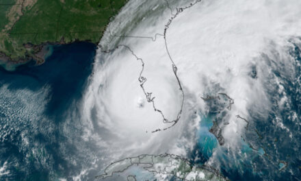
A Major Hurricane Photographed From Space
Image via David Mark at Pixabay


