

From Landfall in North Carolina to Quebec, Canada Isaias Breaks Records
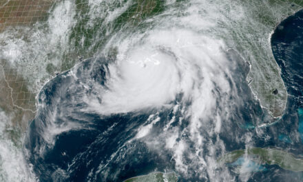
Hurricane Isaias struggled across the Eastern Atlantic as a Possible Tropical Cyclone Storm while it battled increasing wind shear and dry, dusty air from the Sahara Desert. Despite predictions that it would organize into a depression at any moment, it took until Tuesday July 28th before it became a tropical storm without an official designation as a tropical depression. By then the storm was bearing down on the Leeward Islands and taking aim on Puerto Rico and the Dominican Republic.
Late on Thursday, as it left the Dominican Republic behind, the forecast for Isaias included hurricane warnings for the Bahamas and residents in Florida began to prepare. Only an hour after leaving the Dominican Republic, the storm strengthened into a hurricane with 80 MPH winds —much faster than the forecast advisory issued at 11:00 PM Eastern Time. Twelve hours later, the first hurricane watches were issued for the East Coast of Florida and the predicted track had shifted closer to land. A possible landfall in the Carolinas appeared more certain than not.
As it passed over the Bahamas, wind speeds grew to 85 MPH. By Five AM Saturday, the chances for landfall in North Carolina increased.
Hurricane Isaias left an estimated 10-million people without electricity. As of Wednesday, at 12:00 PM, utility crews worked on restoration efforts for millions of customers. New Jersey topped the list of outages with 1.4-millon customers without power. As of Thursday at 10:00 AM EDT, 2 Million customers remained without power. FEMA Recommends Emergency Power Source for Preparedness
Isaias Deals Florida a Glancing Blow
East Coast Florida had hurricane warnings, tropical storm warnings, and storm surge warnings. The storm center was expected to pass within miles of the coast. Close interaction with land would cause some weakening. Through Saturday and Sunday, Isaias inundated Florida with rain, high winds, and moderate storm surge.
As quickly as Isaias had strengthened to a hurricane after leaving the Dominican Republic, Isaias weakened to a tropical storm with 65 MPH winds and at the same time slowed to just 8 MPH. Sunday morning found the storm just off the Florida Coast at West Palm Beach. Forecasters expected a gradual increase in speed as it headed for the Carolinas.
As the storm moved north and further away from land, it regained strength over the warm Atlantic Ocean waters. Early on Monday, it became apparent that Isaias would hit North Carolina as a hurricane.
Storm Preparations in North Carolina
Long before the storm reached Florida, people like Jim and Melinda Bessey were ready for whatever Isaias brought. They had a well-stocked pantry, some conventional plans, and a few unconventional ideas for riding out the storm. Conventional battery-powered fans, lights, and radios that run on 18-Volt batteries. USB ports on the radios and lights for charging phones. Batteries charged and ready. The safe space in a master bedroom closet ready for them and the dog too.
A look at Isaias as it passed Florida & remains a tropical storm but is expected to be a Cat 1 Hurricane as it approaches landfall along the Carolinas.
— Dominique Jackson (@RapSheetTv) August 4, 2020
Be Safe everyone ????????#TropicalStormIsaias#hurricaneIsaias #HurricaneSeason2020 #Isaias pic.twitter.com/7XcTn37MP4
And just for ambiance, solar powered landscape lights brought in from outside. They were ready for the power to go out and knew that it would.
Vehicle gas tanks full. Last minute trips to the store for a few essentials. Stowing outdoor furniture where it wouldn’t blow away. Stocks of water plus more in the freezer to use up space and help keep the freezer from thawing.
With four hours left before the arrival of Isaias and skies completely overcast, all was quiet. They made one last quick trip to the store. Everything was ready, all they had to do was make sure anything left outside was tied down.
When you’re prepared the way Jim and Melinda were ready, you can think about the comforts and things to do next time.
“We realized we should make an extra pot of coffee, but don’t have a proper container for it. Next time. We do have a camp stove, which we hope to leave in the box.”
Storm surge in Garden City Beach is now coming into the pool of our hotel and around oceanfront homes. #Isaias pic.twitter.com/0Of7XDSPSt
— Chris Spiker (@ChrisSpikerTV) August 4, 2020
Potential #isaias (now a hurricane)power outages. pic.twitter.com/nt9ct8Wty2
— Jim Cantore (@JimCantore) August 4, 2020
The first tornado warnings came at sunset and at least one tornado came within a mile of their home. By 10, they had more tornado warnings and the news talked about 100 MPH wind gusts, 30 MPH higher than forecasts earlier in the day.
Sometime before 11, the power went out and they were on battery power. The solar yard lights made things a bit nicer as a jumble of conflicting news reports came over the battery powered radio. Wind and tornadoes were the big news throughout the night. Isaias left Wilmington faster than it arrived and headed north. By 10 AM on Tuesday, the clouds were gone and replaced by bright blue skies.
“The good news is, there’s nothing we need anyway, since we were ready. The smart plan is to get some sleep, and then get back to work this afternoon.”
“Like nothing ever happened.” ~Jim Bessey
When the power came on, Jim made more coffee.
Isaias Drowns Maryland
Shortly after landfall, Isaias lost some strength, but not much. With 70 MPH sustained winds and heavy rain, it headed North and began to affect Maryland on Tuesday morning. The news filled with images of flooding and cars under water. Water rescues from streets like swollen rivers and businesses filled with water and mud.
Dawn Jester in Maryland said, “The afternoon of August 4, 2020 was not just another afternoon in Cecil County, Maryland. It was another round of battering by mother nature in this year of not-so-good cheer.
“We received warnings about the storm for days. This isn’t the first time that we have received such warnings. We have been down this road numerous times in the past and each time we act surprised as if it never happened before. For some, I suppose they may not have been old enough to remember the storm of 1999, Floyd. It [Isaias] hit us just as bad and in the same places. You can’t live near water and expect it not to flood.”
“Winds struck up and you could hear it pushing against the windows. It’s not a beating wind where you hear it slamming up against the house. It’s a constant pressure you can feel in your ears. Just one more ounce of pressure and you know the windows will shatter. The best plan is to move away from the windows, turn off your electronics and wait it out. Then you hear the rain start battering. It doesn’t fall gently or straight to the ground. It pounds the windows as it slams in from a sideways stance. You might think it was a hailstorm, it is that loud, and it goes on and on forever.”
Dawn said a large tree in their backyard was uprooted and splintered as it fell with three loud explosion-like crashes. She went on to talk about the damage and flooding.
Power outages have exceeded 3.5 million across the eastern US in the wake of #Isaias. New Jersey accounts for more than 1/3 of the outages: https://t.co/hlOtkYoS7Y pic.twitter.com/EW4vmwCJzD
— AccuWeather (@breakingweather) August 4, 2020
What Will My Portable Generator Run During a #PowerOutage? #Outage #hurricaneIsaias https://t.co/5S30yUCJQF
— Michael Williams (@Author_MJLogan) July 31, 2020
“The devastation around the county is heartbreaking. Reports say the *beauty shop where my sister works went under water. She and everyone who works there is safe and sound, but she fears this might close them down for good.”
“Sirens sounded all day as rescue pulled people from the water. One man was reported floating on an air mattress. I don’t know what happened to him. They said he needed help and were unable to get to him.”
Now that the storm has passed, Dawn is helping where she can.
The fast-moving tropical storm remained strong on its way out of Maryland and through New York and Vermont. After it crossed into Canada it finally became a post-tropical storm, but still packed strong 50 MPH winds.
By Thursday afternoon it was over east-central Quebec, Canada near the Newfoundland-Labrador border as a post-tropical depression and 40 MPH wind. The National Hurricane Center issued its last public advisory on Wednesday, August 5, at 05:00 AM.
*Update: Dawn later said the report was incorrect and her sister’s shop was spared. Other businesses did not have the same happy ending.


